TÍÐINDI
- Bjargingarbáturin "Arun" fingið heimstað á Tvøroyri 21. november 2025
- Tvøroyri -destinatión hjá Nordic Port Group 21. november 2025
- Tvøroyri styrkir sín leiklut í altjóða ferðamannaskipsvinnuni 15. november 2025
- Kongshjúnini, H.M. Kong Frederik og H.M. Drotning Mary vitja á Tvøroyri tórsdagin 12. juni 2025 6. juni 2025
- Umhvørvismálaráðið staðfestir umhvørvisgóðkenningina til P/F Varðin Pelagic 8. apríl 2025
- Yvirfriðingarnevndin góðkennir útbygging av havnaøkinum á Tvøroyri 23. mars 2025
- KVØÐA TIL HDMS TRITON & ARTIC KOMMANDO 16. mars 2025
- BJARGINGARBÁTUR HANDAÐUR TILBÚGVINGINI 1. februar 2025
- P/F Varðin Pelagic fingið byggiloyvið 18. januar 2025
Tvøroyri Today – Existing Port and Maritime Infrastructure
Port of Tvøroyri
Tvøroyri is home to one of the most established ports in the Faroe Islands outside of the capital region. The port facilities are located within Trongisvágsfjørður, a sheltered natural fjord on the east coast of Suðuroy.
-
Existing quays: The port already provides multiple quays for fishing vessels, coastal shipping, and cargo handling.
-
Fishing industry base: Tvøroyri has a strong tradition as a fishing and maritime service hub, with processing plants, cold storage, and supply facilities for vessels.
-
Logistics connections: The port connects directly to the main road network on Suðuroy, linking communities across the island and enabling onward transport to the ferry terminal at Drelnes (Smyril Line domestic ferry to Tórshavn).
-
Harbor services: Bunkering, repair workshops, and general supplies are available, making Tvøroyri an active maritime community.
Trongisvágsfjørður – Natural Advantages
The fjord of Trongisvágsfjørður provides exceptional natural conditions for port activities:
-
Sheltered waters: The fjord is naturally protected from the open Atlantic, ensuring calm berthing conditions year-round.
-
Depth: The fjord has naturally deep waters close to shore, suitable for larger vessels without major dredging.
-
Industrial shoreline: Both Tvøroyri and the nearby village of Trongisvágur already host industrial areas along the fjord, making it suitable for further maritime expansion.
-
Environmental potential: The combination of sheltered location, available shoreline, and upcoming infrastructure projects makes the fjord a key area for sustainable harbor development in the Faroes.
Present Role and Future Potential
Today, Tvøroyri and its port facilities serve as a regional hub for fishing, fish processing, coastal shipping, and local logistics. With its sheltered fjord and maritime infrastructure, it already functions as a reliable service point for vessels in Suðuroy.
Looking ahead, these existing strengths form the foundation for further development into a maritime hub and offshore supply base, as well as a potential terminal for a regular ferry link to Scotland. By building on what is already established, Tvøroyri can expand in a way that is both practical and future-oriented.
Background
Tvøroyri Municipality is planning a new harbor area based on land reclamation in Trongisvágsfjørður. The area will be developed using surplus rock material from the upcoming Suðuroyartunnilin project, creating both environmental and economic synergies.
Some info about the projekt "suðuroyartunnil" >>>👉 her
Planned Area
Reclaimed land area: ~127,886 m²
Fill volume: ~1,219,000 m³
Located directly adjacent to existing port facilities and infrastructure.
Connected to road network and potential logistics hubs.
Concept & Opportunities
Deep-water quays: New quay structures with depths of -10 m and beyond, suitable for offshore supply vessels, subsea construction units and cargo ships.
Large laydown areas: Open storage and logistics base capacity for OCTG, subsea modules and heavy lift.
Industrial plots: Space for warehouses, workshops, logistics companies and service providers.
Green port concept: Integrated with shore power, waste reception, and sustainable energy solutions.
Strategic location: Sheltered fjord with short steaming distances to West of Shetland oil and gas fields.
Advantages
Uses excavation material from Suðuroyartunnilin – cost-effective and sustainable.
Scalable area: can be expanded in stages according to demand.
Strengthens Tvøroyri’s role as a maritime hub for the Faroes and as potential offshore supply base.
Direct synergy between municipal planning and international industry needs.
Next Steps
Feasibility and engineering studies in cooperation with contractors.
Market dialogue with oil & gas operators, offshore service companies and logistics providers.
Public-private partnership opportunities for quay and infrastructure investment.
Target: establish functional new harbor area 2035.
***
The proposed harbor development, as illustrated in the plan, is designed to utilize waste rock from the Suðuroy Tunnel project for strategic land reclamation. The filled-in area will create a new landmass along the shoreline, providing both additional industrial space and improved maritime facilities.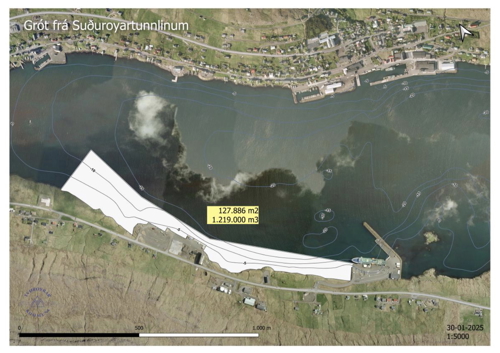
The plan indicates a reclaimed surface of approx. 127,886 m² with a fill volume of around 1,219,000 m³. This newly established harbor area will be suitable for:
-
Expansion of quay facilities to accommodate larger vessels and increase shipping capacity.
-
Industrial development zones, providing land for future businesses linked to maritime services, fishing, aquaculture, and logistics.
-
Improved transportation connections between sea and land, ensuring easier access for goods distribution and regional commerce.
-
Strategic storage and operational areas for ferry operations, container handling, and potential future offshore industry.
By combining the tunnel project’s waste rock with long-term harbor expansion needs, this solution ensures that the material is reused effectively, reducing environmental impact while creating lasting infrastructure improvements.
The project also supports Tvøroyri Municipality’s long-term vision of strengthening Suðuroy’s position as a key maritime hub, providing new opportunities for economic growth, employment, and sustainable development.
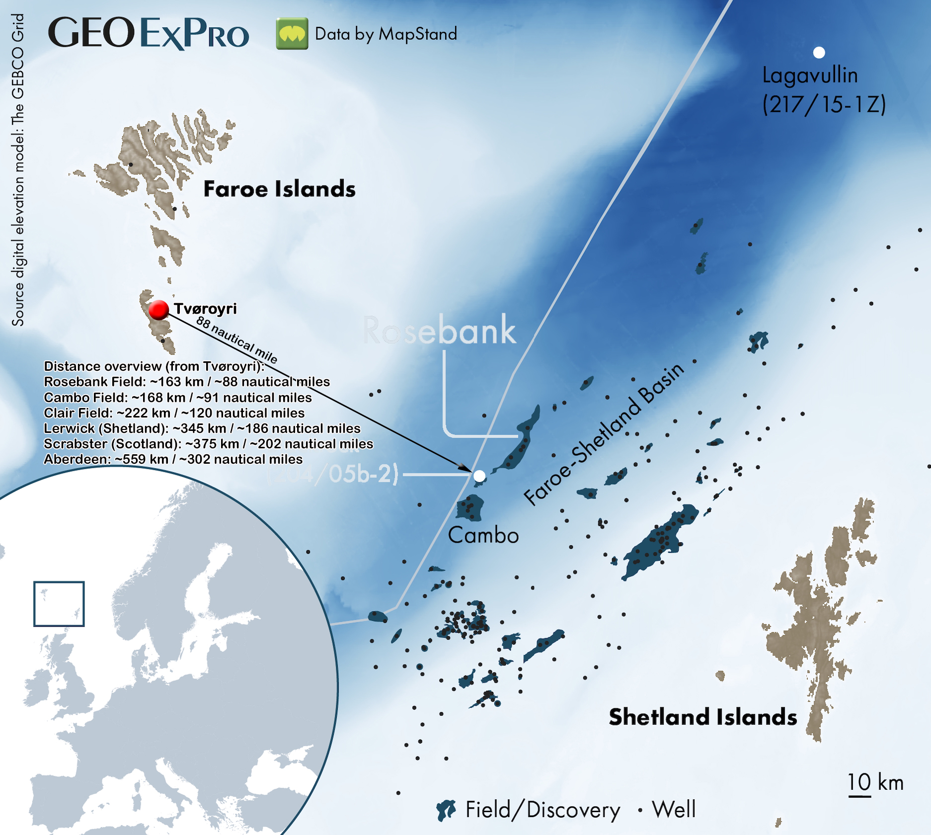
Here’s the full distance overview (from Tvøroyri):
-
Rosebank Field: ~163 km / ~88 nautical miles
-
Cambo Field: ~168 km / ~91 nautical miles
-
Clair Field: ~222 km / ~120 nautical miles
-
Lerwick (Shetland): ~345 km / ~186 nautical miles
-
Scrabster (Scotland): ~375 km / ~202 nautical miles
-
Aberdeen: ~559 km / ~302 nautical miles